
Current Environmental Conditions
Offsite Groundwater and Response Action
Private Well Monitoring
Based on the finding of VOCs in the well installed immediately south of the former Kop-Flex facility in 2012, MDE and EMERSUB 16, LLC initiated four separate phases of residential well sampling in the area to the south of the former Kop-Flex facility property and Maryland Route 100. This resulted in the collection of water samples from approximately 190 private water-supply wells. Detectable levels of VOCs were found in 150 water samples collected from these water-supply wells. Most of these detections consisted of trace to very low concentrations of methyl tertiary-butyl ether, an additive formerly used in gasoline, and/or trihalomethanes (especially chloroform), which are common byproducts in the disinfection of well water using chlorine. These VOCs are not associated with the Kop-Flex Site.
Constituents that occur at the site (i.e., chlorinated VOCs and 1.4-dioxane) were detected in 22 of the well samples, with most of these wells located north of Reece Road. Because hydrogeological data indicates that the groundwater contamination emanating from the former facility property is restricted to the deep zone of the Lower Patapsco Aquifer, chlorinated VOCs and 1,4-dioxane detected in water samples from wells screened in the shallow aquifer zone are believed to be related to contaminant sources other than the former Kop-Flex property.
Of the 22 wells that contained constituents found at the site, water samples from ten wells along Twin Oaks Road and Old Camp Meade Road had chlorinated VOC and 1,4-dioxane concentrations above either federal or state groundwater quality standards, or state risk-based criteria. These wells have since been decommissioned and the homes connected to the municipal water system, though data generated since the time of the water main connection suggests that some of the contamination was caused by releases from sources besides the former Kop-Flex facility property.
Figure 3
View full-size version of Figure 3
In the Andorick Acres neighborhood, the compound 1,1-DCE was also detected above the applicable groundwater quality standard in the sample from a residential well. Given the lack of public water mains in this residential community, EMERSUB 16 proposed installing a replacement well on the property to provide a new source of potable water. The MDE and USEPA conditionally approved the installation of the replacement well in January 2017, provided the new well is completed in the upper, uncontaminated portion of the Lower Patapsco aquifer system and sampling indicated the absence of site-related VOCs in the well water. In late February 2017, the replacement well was installed and connected to the residence and the exiting VOC-impacted well abandoned on the property. Subsequent sampling of the well water by the Anne Arundel County Bureau of Environmental Health and EMERSUB 16's consultant indicated that the treated water met the applicable water quality criteria and was safe for domestic use. A Conditional Certificate of Potability for the replacement well was provided to the homeowner by Anne Arundel County in early June 2017.
Figure 4
View full-size version of Figure 4
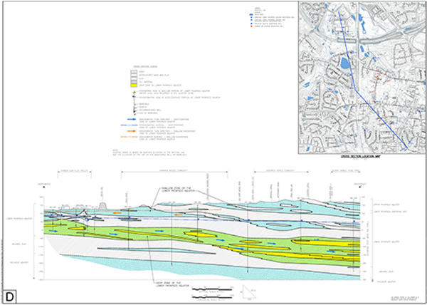
Figure 3 provides a cross-section, or vertical slice, through the subsurface that depicts the sequence of sandy aquifers and clayey confining units (termed aquitards) in the Hanover-Severn area, as inferred from publicly available hydrogeological studies and EMERSUB 16, LLC's field work.  Based on hydrogeological information, two aquifers - Lower Patapsco and Patuxent - which are separated by the predominately fine-grained (silt and clay) deposits of the Arundel Clay confining unit, are present beneath the former Kop-Flex facility and offsite area to the south and east. The Lower Patapsco aquifer is divided into shallow and deep zones by the presence of clayey layers that serve as intra-aquifer aquitards.
Figure 5
View full-size version of Figure 5
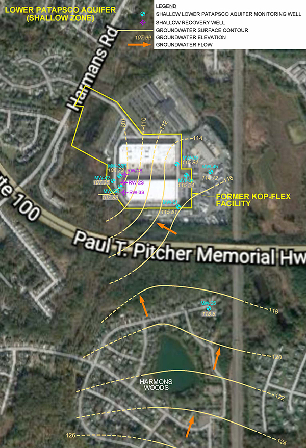
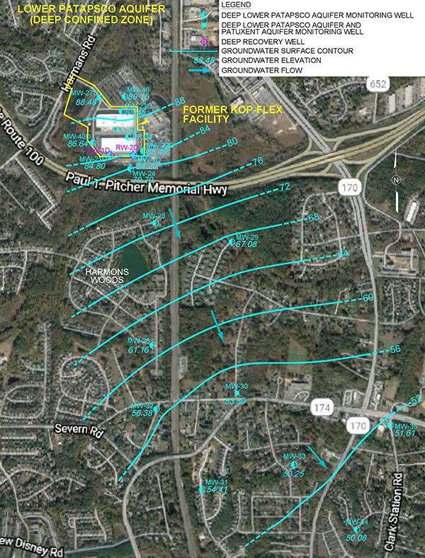
The direction of groundwater flow in the different aquifer zones within the Lower Patapsco aquifer dictates the subsurface distribution of contaminants caused by releases at the former Kop-Flex facility property. As depicted in Figures 4 and 5, groundwater in the deep zone of the Lower Patapsco Aquifer and the Patuxent Aquifer flows to the south-southeast from the former facility property, whereas groundwater in the shallow zone of the Lower Patapsco Aquifer flows to the north and west in the area of the former facility property.  In addition, groundwater can move downward from the shallow zone of the Lower Patapsco aquifer to the deep zone due to a vertical gradient caused by differences in the fluid pressure within the sandy deposits comprising each zone. The downward vertical gradient would prevent the upward flow of groundwater and contaminants from the deep zone to shallow zone. Given this understanding of the groundwater gradients, and the fact that the thick aquitard between the deep zone of the Lower Patapsco Aquifer and the Patuxent Aquifer has a very low permeability, site-related contaminants that have migrated to the area to the south of the facility property are confined to the deep zone of the Lower Patapsco Aquifer. The table below provides information on the depths below ground surface for the top and bottom of the deep zone of the Lower Patapsco aquifer and top of the underlying Patuxent aquifer. The areas/locations in the table are listed with increasing distance south-southeast from the Former Kop-Flex Facility.
| Location/Area | Depth to Top of Deep Zone of Lower Patapsco Aquifer (FT BGS) | Depth to Bottom of Deep Zone of Lower Patapsco Aquifer (FT BGS) | Depth to Top of Patuxent Aquifer (FT BGS) |
|---|---|---|---|
| Southern Boundary of Former Kop-Flex Facility | 100 | 165 | 280 |
| Intersection of Siden Drive & Kidwell Drive, Harmans Woods | 112 | 190 | 300 |
| Intersection of Gesna Drive & Fairbanks Court, Harmans Woods | 140 | 215 | 345 |
| Intersection of Twin Oaks Road & Old Camp Meade Road | 208 | 310 | 378 |
| Bittersweet Road, Andorick Acres | 220 | 360 | 400 |
| Intersection of Gander Way & Fair Breeze Drive, Severn Mobile Home Park | 225 | 380 | 435 |
FT BGS = feet below ground surface
In summary, review of the available well information shows that residential wells in the areas south of the former Kop-Flex property are screened in both the shallow and deep zones of the Lower Patapsco aquifer. However, given the nature of groundwater flow within the aquifer, the presence in private wells of contaminants related to the former Kop-Flex facility can only occur in wells screened within the deep zone of the Lower Patapsco aquifer that extends to the south and east from beneath the Former Kop-Flex facility. This zone becomes progressively deeper as one moves away from the southern boundary of the former facility property. Thus, it occurs at a depth between 100 to 165 feet BGS along the southern boundary of the former facility and at a depth of 225 to 380 feet BGS near the Severn Mobile Home Park along Telegraph Road. Chlorinated VOCs and 1,4-dioxane detected in water samples from private wells screened in the shallow zone of the Lower Patapsco aquifer cannot be related to releases and historical operations at the former Kop-Flex property.
Groundwater Monitoring Activities
Since 2014, groundwater investigation activities have been conducted to further assess the offsite contaminant distribution. These investigation activities involved the installation of 3 monitoring wells in the shallow Lower Patapsco aquifer zone, 12 wells in the deep Lower Patapsco aquifer zone, and 2 wells in the Patuxent aquifer. These wells are located between 100 feet and 1.5 miles from the former Kop-Flex facility. At present, the offsite monitoring wells are sampled on a semi-annual schedule.
No site-related contaminants have been detected in the samples from the offsite monitoring wells screened in the shallow zone of the Lower Patapsco aquifer or the Patuxent aquifer, which is separated from the deep sandy zone of the Lower Patapsco aquifer where site-related VOCs have been detected, by a thick, predominately clayey unit (Arundel Clay). Chlorinated VOCs and 1,4-dioxane associated with the Kop-Flex site are limited to the sand deposits present in the deep confined aquifer zone. This data suggests that any VOC-contamination in offsite wells in the shallow aquifer stems from other source(s) and not from releases at the former Kop-Flex facility property.
In the area south of Maryland State Route 100, levels of 1,1-DCE above the groundwater quality standard have been detected in samples from the paired deep aquifer monitoring wells MW-25D-130 and MW-25D-192 in the Harmans Woods residential area, and well MW-30D-273 at the intersection of Twin Oaks Road and Old Camp Meade Road. Additionally, the concentration of 1,4-dioxane in samples from these deep aquifer monitoring wells exceeded the MDE risk-based action level. The sampling data for the deep monitoring wells located further to the south and east contained either non-detectable or low concentrations of the site-related constituents. The concentrations of 1,4-dioxane detected in samples from MW-33D-295 are slightly above the MDE risk-based action level. Other than the detections of 1,4-dioxane in the groundwater samples from well MW-33D-295, no site-related contaminants have been detected above the applicable groundwater quality criteria in any of the recent samples from the other downgradient monitoring points in the deep aquifer zone. A statistical evaluation of the sampling data for the wells generally indicates stable or decreasing trends in the concentrations of site-related constituents, indicating some degree of stability concerning the extent of the contaminant plume in the area. Overall, the extent of affected groundwater in the deep aquifer zone downgradient of the former Kop-Flex facility is delineated by the offsite monitoring well network.
Based on evaluation of the sampling data, the deep zone of the Lower Patapsco aquifer constitutes the pathway for the migration of contaminants to the residential neighborhoods to the south of the of the former Kop-Flex facility. Moreover, the regional southeastward dip of the sandy and clayey layers within the Lower Patapsco aquifer results in a corresponding increase in the depth of the contaminant plume in the downgradient (south-southeast) direction. Accordingly, the contamination occurs at increasingly greater depths the farther one moves away from the site toward the south-southeast.